NTUA DEPARTMENT OF ARCHITECTS AND ENGINEERS_ SECTION III ARCHITECTURAL LANGUAGE – COMMUNICATION & PLANNING_ DIPLOMATIC WORK_ ATHENS 1999 “CENTRE OF MESSOMANIAN RESEARCH OF THE TIGANI PENINSULA”
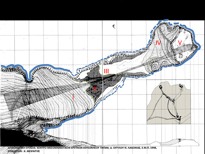


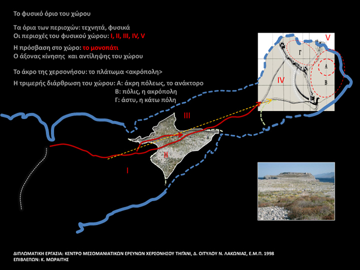


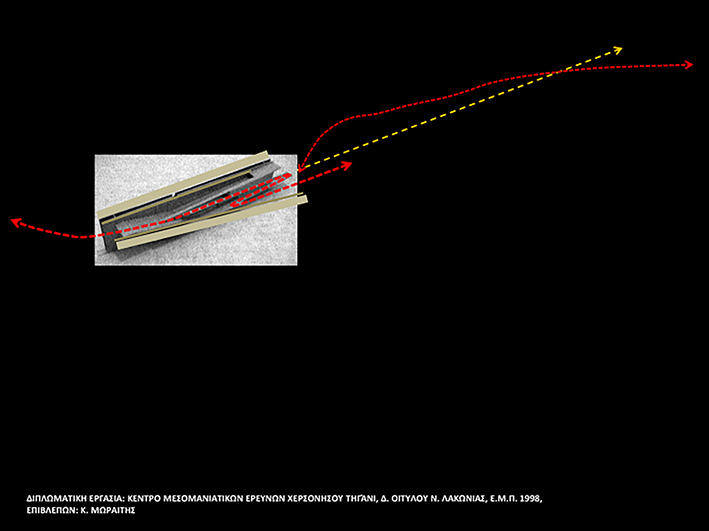
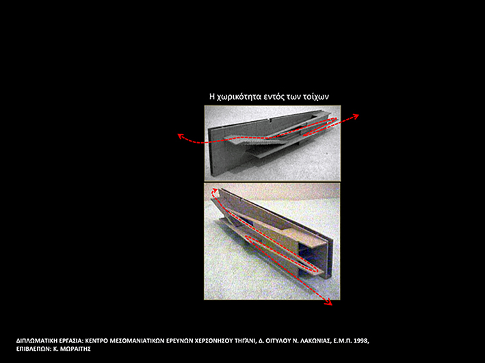

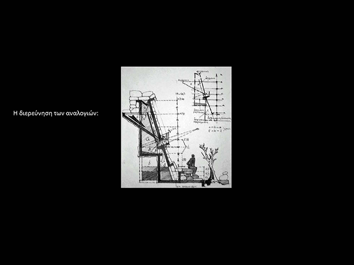
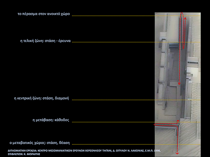
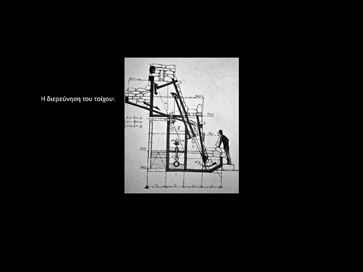
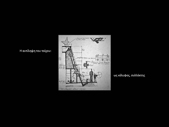
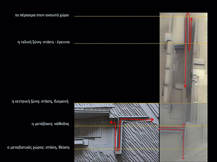
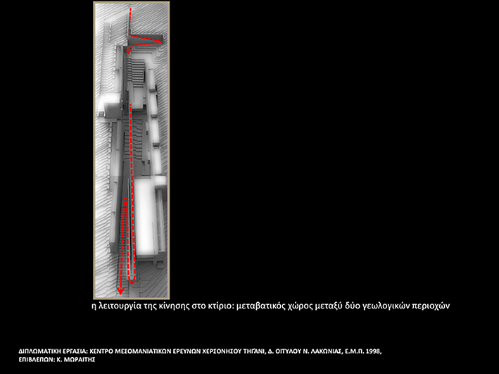
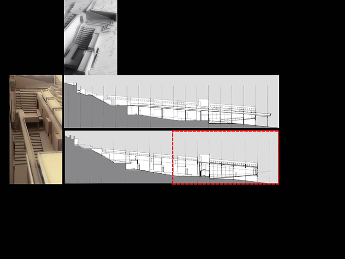
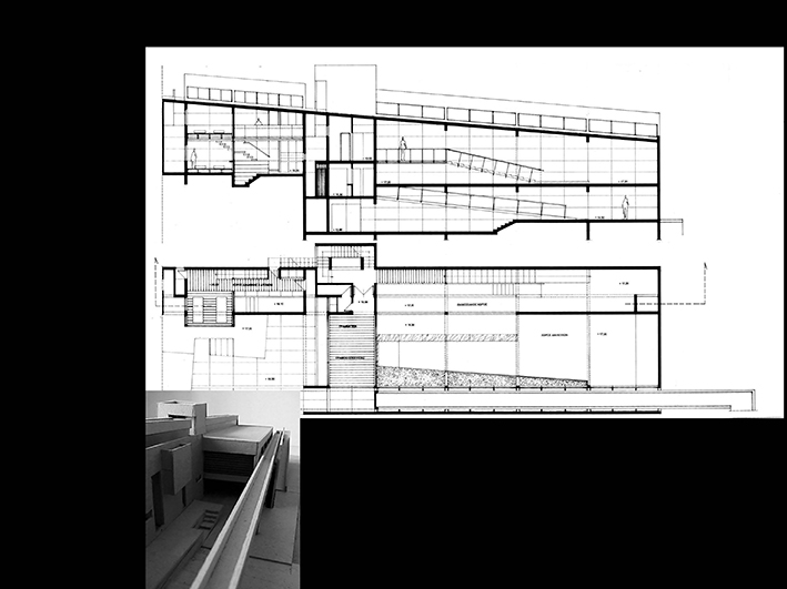
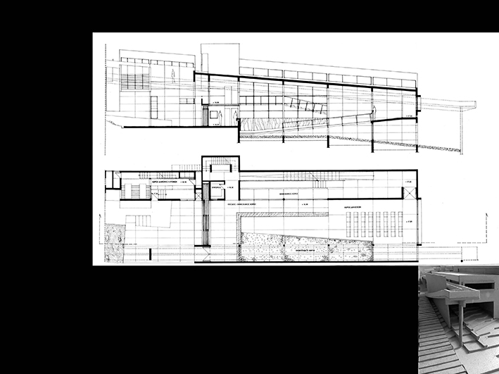
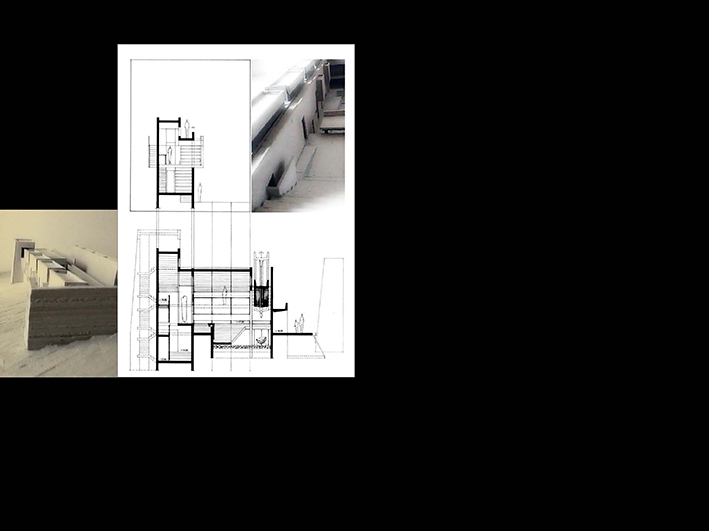

The place of intervention is Cape Tigani in the area of Mesa Mani in the Province of Laconia at the southernmost tip of the Greek land. It is an area of ancient habitation on a narrow strip of land surrounded by the sea and is characterized by the absolute stripping of the natural landscape. The name ‘pan’ comes from the overall shape of the peninsula. Historically: The castle of Teganio is located opposite the small beach of the village of Mezapos, which is also referred to by Pausanias in his tour of the Laconians during the circumnavigation of Tainaros, as the ancient Messis. The narrow, low-altitude, and rocky peninsula are scattered with stones. Its seaward end, the highest and steepest, is formed into a natural fortress whose passable parts have been fortified during Byzantine times. The only entrance to the fort is located in the SE corner next to the steep rock, which was protected on the left by a corner tower. A plan of the fort against Water House R. Hope Simpson shows two other corner towers one in the middle of the south side and one in the SW corner. And the way of structure is similar to the buildings of Mystras. According to English archaeologists, the fortress is identified with the castle of Mani, built by William Villeardouino in 1250. In the area of the castle, there are many rainwater tanks (rainwater). Outside of it, the pile of a continuous megalithic rampart can be seen. Near the entrance and inside the fort, a temple was excavated measuring 14 meters in width and 23 meters in external length on the southern side. The church is a three-aisled basilica with a narthex. The sculptures of the temple belong to the early Christian times and many to the Byzantine era. It is possible that the monument dates back to the 6th century and was the cathedral of the diocese of Mani (conclusion of excavations 1964). At the NW end of the pan and despite the edge of the cliff remains the ruin of a temple where part of the arch and its southern wall is preserved. To the east are the ruins of individual settlements, of which the second one is larger with a tank to the west, conclusions from excavations 1977). From the 1978 excavations, the most important findings are of the 6th-century carvings used in the masonry of the basilica and suggest the existence of an earlier monument possibly associated with the lower part of the north wall. The temple, which in the 12th century was limited to the middle aisle, was probably destroyed by an earthquake. Along with surviving parts of the basilica at a time when life had faded. This probably happened during the Frankish conquest which resulted in the departure of the Byzantine garrison from the castle of Mani. The consideration of the castle as a military and administrative center of the region and that it can be identified with the castle of Mani is evidenced by an inscription of the 12th century with reference to the active presence of a Byzantine official (count). Excavations in the 1980s revealed evidence of tombs on the lower level of the temple carved into the natural rock. Excavations continued until 1986 when they were stopped. (See Proceedings of the Archaeological Society. The object of work: It is a complex building that includes a series of temporary accommodation spaces for the research archaeologists where they will work in the castle area for the completion of the excavation work and the partial restoration of the area. The research and restoration are not limited to the area inside the castle but include the entire peninsula with the salt flats, which are a remarkable example of traditional architectural heritage. The building has an exhibition area of past excavations and the remaining remarkable parts of Byzantine art and structure. This same space gives a possibility of alternative uses in terms of its function as it has the ability to be transformed into a meeting place for lectures and discussions with a capacity of (40) people. It also has a library and information space about the history of the place. Laboratory research area of the scientists, where it is completed with the supervision office and the secretariat. It is also covered by an (independent) refreshment area, with expansion into the central atrium (courtyard) and auxiliary catering and mechanical facilities areas. This complex building is an experiment of application in the space that defines the uniqueness of the place and the unique access to the place from land. Basic compositional principles: The compositional principles that determine the design of the building complex are the following: a) the descent road axis that faithfully follows the current possibility of access through a path, in this line from the building point to the end of the land the building it looks like a pointer, a crosshair for seeing the place that turns towards the tip of the peninsula. b) The inclusion of the building in a plastic transversal folding of the relief. The body of the building does not simply rest on the earth, but through the excavation itself the relief of the ground is made, this excavation is the marking of the building and the building forms part of the earth as it follows the slope of the ground along. c) The perception of the wall, where sometimes the wall is imposed by the production of closure and its mass, and sometimes the wall consists of a building (shell), to house human activities and cover water needs. d) The building with its mass and its walls tries to preserve the necessary shade and water that are lacking in the place and where their absence is evident during most of the year due to the bareness of the ground. e) The way in which light enters is highly controlled as the light slides into the container (building) and where the interior is a structured space that challenges viewing through slits. Building plan – Sections Research center: Entrance – Exhibition area – Lecture hall – Concierge – W.C – Warehouse – Staircase (elevator) – Supervision office – Secretariat – Research laboratories – Storage of finds – Auxiliary staff area. Tower (library): Entrance – Lobby – Information – Information desk – Supervision area – Libraries – Reading area – Supply elevator. Refreshment: Outdoor area (courtyard) – Outdoor amphitheater. Accommodation: – Accommodation (4) people – Accommodation (2) people – Supervision accommodation. Tanks (rainwater) Water collectors-Water reservoirs. Description of building function: The building integrated into the natural relief, functions through the movement – route on the descent axis, as a transitional space between two different geological areas. This transition also marks the transition from the open outdoor space to the ‘designated’ public space and from the open to the controlled public flow. The location and use of the building make the center a multi-purpose space, as the passage becomes a stop for information and rest, while at the same time it is a place for researchers to stay and work. It becomes a meeting place for researchers and the public as the museum preservation on the peninsula gives the public the possibility of more direct communication with the cultural heritage of the place. Note This opinion supports the need to preserve and protect the whole place as a remarkable landscape of historical importance and the protection of the wider area of the peninsula, as an open museum of cultural and natural heritage…
